Ohakune
The Old Coach Track
Ohakune Walks and Cycle Trails
Mountains to Sea Cycle Trail
Distance: 217km
Time: 3 - 6 Days
Start Point: Ohakune Junction.
Difficulty: Moderate
From the fringes of Mt Ruapehu to the coastal shores of Whanganui, this route encompasses majestic mountains, stunning native forest within two National Parks, and the spiritual, cultural and historical highlights of the Whanganui River.
The Mountains to Sea Cycle Trail takes in the alpine grandeur of Mt Ruapehu, historic coach road and bridle trails, the legendary Bridge to Nowhere, jet boat and kayak transport options for the Whanganui River link to Pipiriki. From there a country road trail abundant with history and culture alongside the Whanganui River links Pipiriki to the Tasman Sea at Whanganui.
The trail is a joint initiative involving the Ruapehu District Council, Whanganui Iwi, Whanganui District Council, Department of Conservation and the New Zealand Cycle Trail project.
Suitable for all abilities of cyclists, the trail includes a mixture of off and on-road trail, which can be enjoyed in sections or in its entirety. It’s recommended that you start from Ohakune which offers a 217km journey [including a 32k river section which will be completed by boat or kayak] which is a grade 2-3 ride.
There is an alternative start from National Park which is slightly shorter at 209kms [including the river section] however this does include a grade 4 section so is recommended for more experienced riders only.
Ohakune Old Coach Road
Distance: 11km
Time: 5 hours one way
Start Point: Horopito Junction, 14.5km from Ohakune. Transfers available.
Difficulty: Moderate
Ohakune Old Coach Road is an Iconic part of New Zealand history .It provided an all-weather access road for horse drawn coaches carrying passengers and cargo between Ohakune and Raurimu the two railheads of the main trunk line. Progress was slow on the completion of the rail link ,in the meantime the road provided a viable access link, until the gap was finally closed on 7th August 1908 for the Parliamentary Special carrying the Prime Minister Sir Joseph Ward and other parliamentarians north to see the American Great White Fleet at Auckland.
The road mostly followed the old bridle track completed in 1886 which was upgraded to a dray road in 1895. In 1904 work started on upgrading the road which was completed in 1906. The road is a very significant example of New Zealand engineering heritage and the finest rural road constructed up to that time. It has great historic significance relating to that period and was used until early 1909. The road remained unused and some sections of it were lost in 1987 when the railway was diverted.
The road is in remarkably good condition considering the length of time it has been out of use ,and the effects of natural deterioration .When you walk down this road today one is transported back in time to a magical bygone era of yesteryear. Today it has a Category I Historic Places status from the Historic Places Trust
The establishment of such an historic and unique walkway provides visitors to the area not only with an alternative activity when the ski fields are closed but also provides railway enthusiasts with an opportunity to see how the two railheads, one in Ohakune, the other in Horopito were linked by coach and horses prior to the completion of the Main Trunk Line.
The Ohakune Old Coach Road can only be accessed from Ohakune. There are two locations that visitors can start their journey, these are either from the historic Ohakune railway station, or the Marshalls Road car park located a few minutes drive from the Ohakune Junction.
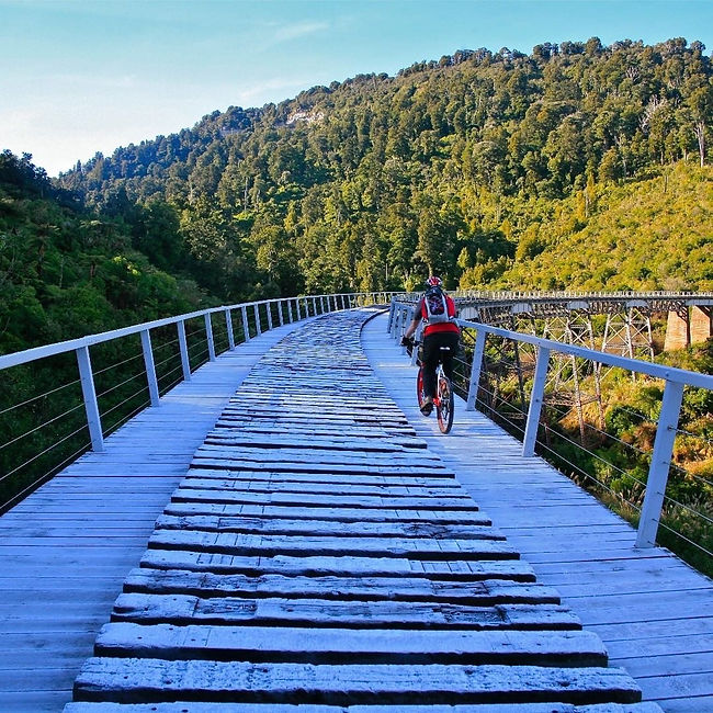
Hapuawhenua Viaduct
At the edge of the old rail alignment, stage one of the historic Ohakune Old Coach Road ends and visitors travel along a new section of track towards the historic Hapuawhenua Viaduct. Along the way, the historic Hapuawhenua Tunnel can be entered and walked for around 200m, though there is only one entry/exit point. After winding around the hill the track drops down to the two Hapuawhenua Viaducts - passing under the new and heading out to the historic viaduct.
This spectacular viaduct was completed in 1908 and was a vital link in the final stage of the long awaited main trunk railway between Wellington and Auckland . In total the viaduct is 284 metres long and at its maximum it stands 45 metres high. It is unique in that it is built on a 10-chain radius curve, reflecting the difficult terrain and challenging landscape the designers had to contend with.
Both the Hapuawhenua and the Taonui Viaducts were designed by Peter Seton Hay, Chief Engineer of the Government Public Works Department, and considered to be one of the most influential engineers at that time.
The viaduct is constructed on 13 concrete piers and four 4 legged steel towers resting on concrete foundation. There are four steel plate girder tower spans of 11 metres, five 20 metre lattice truss spans and thirteen 11 metre plate girders.
Workers lived on site during the two years it took to construct the viaduct, during that time they worked through very harsh winters, primitive living conditions and isolation in order to complete construction in time for the opening of the railway. Today it is mostly in original condition, and has recently been restored by. Ohakune 2000 , DOC and the Tongariro Natural History Society to become part of the exciting new walkway and cycleway known as the Ohakune Old Coach Road allowing visitors to enjoy this spectacular piece of railway heritage. The viaduct has a Category I Historic Places status from the Historic Places Trust.
Lake Surprise
Distance: 9km
Time: 5 hours return
Start Point: 15km from Ohakune on the Ohakune Mountain Road
Difficulty: Moderate
The walk to Lake Surprise is a mountain walk which we feel is on a par with the Tongariro Crossing, but without the crowds. This is a walk which has been ground out of the land by massive glacial and volcanic activity. Although at times it felt like we were in the South Island, this is in the heart of the North Island - the Lake Surprise walk on Mt Ruapehu.
It begins by stepping off the side of Mountain Road and sidling across some rather steep scree slopes. Once past those, the terrain rises up over classic high country alpine meadows. From the highest point we could look down on the lake, and the classic U-shaped glacial valley which we would cross, as well as the rocky wall of the U to get up out of the valley.
This walk is part of the Round the Mountain circuit so can be done point to point, probably about 10 hours from Whakapapa to Mountain Rd, or in and out from Mountain Rd, as we did. Whichever you do, respect the mountain’s fast changing climate, check the mountain forecast before leaving and be ready for anything.
Like the Tongariro Crossing, Lake Surprise Trail is a dramatic demonstration of the power of the mountain to alter landform. This walk offers more in its journey than in its destination: raw, dramatic and primal .
Similar or better fitness required as for The Tongariro Crossing, with a lot of clambering over rocks; however it’s shorter, taking us 5-6 hrs.
Parking: there is room for only 3 or 4 cars at the beginning of the walk: otherwise there is the #3 carpark for the Turoa ski field just a short way up the road. A bonus here for Middle Earth fans is that last year some of The Hobbit was shot off this car park, using scaffolding to get all the actors down to the waterfall below the road.
The beauty of the Lake Surprise walk is its accessibility for North Islanders. Although it feels like a world away, you can get big mountain drama only 3 or 4 hours drive from most places in the North Island, making it a good weekend trip or a short break. Staying in Ohakune, it’s only 20 minutes drive up Mountain Road, with a heap of other walks to explore while you’re there.
Bridge to Nowhere/Mangapura Track
(Forms part of the Mountains to Sea Cycleway)
Distance: 38kms
Time: 4-7hrs cycling + 1hr jet boat transfer
Start Point: Mangapurua Road, Whanganui National Park
Difficulty: Moderate
The Bridge to Nowhere trail is gaining a reputation as one of the best day rides in New Zealand, combining interesting riding terrain with historical sites and topping it all off with a jet boat transfer down the river.
Through the forest, over the rolling hills, along the sheer face of Battleship Bluff and across the majestic Whanganui River, the Bridge to Nowhere trail offers a fascinating glimpse into post-war life in the central North Island. The variety it offers makes it a great experience for riders of all levels, although some experience is recommended.
In 1917 the Mangapura Valley was opened by the government to encourage settlement by returning World War I soldiers and their families. Up to 35 families lived in the valley at the height of its occupation. Built originally as a means of linking the valley settlements with the riverboat transport service, the bridge was in use for a mere 6 years before the valley was abandoned in 1942.
Follow in the footsteps of the post-war pioneers and visit the settlement plots that still bear the names of the families that occupied them. Then take a walk over the bridge and trade the steam boats for a high powered jet vessel for your return journey.
This ride is best enjoyed as part of an organised tour that will arrange transport to the start point, collect you at the finish and arrange your jet boat experience. These elements are difficult to co-ordinate on your own.
Mangawhero Forest Walk
Distance: 3km
Time: 1 hour return
Start Point: DOC Visitor Centre at the foot of the Ohakune Mountain Road
Difficulty: Easy
Within easy walking distance of the township, Mangawhero Forest Walk is a great introduction to the native forest of central North Island - an abundance of species including broadleaf, kahikatea, kamahi, matai and rimu trees surround the track. Crossing the Mangawhero River, from which it takes its name, the trail descends through the towering kahikatea trees to a swamp-like volcanic crater.
Waitonga Falls
Distance: 4km
Time: 1.5hrs round trip
Start Point: 11km from Ohakune on the Ohakune Mountain Road
Difficulty: Easy – some steep sections
This easy walk through beech and kaikawaka forest and across scenic marshland brings you to the Tongariro National Park’s highest accessible waterfall and the alpine stream below. With picture perfect views of the mountain reflected in the Rotokawa tarn (a shallow mountain pool) and the chance to fully appreciate the valley vistas, this trail is well worth a visit.
The route winds along the wooded slopes of Ruapehu and crosses the Rotokawa marshes on a raised boardwalk finally descending to the base of the falls. The falls are beautiful at all times of the year, but during the winter months the volume of water passing over the falls makes them particularly remarkable. Green hooded orchids and white sun orchids can also be seen along this track.
Carrot Park Walk
Backing right on to the Downtown Apartments at Clyde Street in Ohakune is the new Carrot Park, a must visit for families.